Map Features
Each feature in the list can be toggled on or off to tailor the map experience to your organization’s needs. Selecting a feature provides additional information and access to related configuration options, allowing you to customize how each feature behaves and interacts with other map components.
| Feature | Description | Sub-features / Options |
|---|---|---|
| Record Geolocation | ||
| Enable Map Address Pin | Displays a pin on the map for the configured address field. | Listens to Address, Fire Address Events, Zooms to Address |
| Map Tabs | ||
| Show Search Tab | Enables the search tab for users to find locations and data. | Allow Address Searching, Allow Region Searching, Allow Layer Searching, Allow Layer Feature Searching |
| Show Map Views Tab | Enables users to save and restore map views. | Allow Map View Sharing, Allow Sharing by Code, Only Admin Can Share Map Views |
| Show Layers Tab | Displays the layers tab, allowing users to manage map layers. | |
| Show Shapes Tab | Displays the shapes tab for drawing, uploading, or editing shapes. | Allow Uploading Shapes, Allow Drawing Shapes, Allow Editing Shapes, Allow Deleting Shapes |
| Show Routes Tab | Displays the routes tab for creating and sharing routes. | Limit Number of Routes, Allow Route Sharing, Allow Sharing by Code, Only Admin Can Share Routes |
| Show Measurement Tab | Enables measurement tools for length and area calculations. | Allow Length Measurements, Allow Area Measurements |
| Show Map Filters Tab | Displays the map filters tab for advanced filtering options. | |
| Show AI Agent Tab | Enables AI assistant for contextual help and spatial analysis guidance. | Endpoint URL, Authentication |
| Show Help Tab | Provides access to interactive help resources and user guides. | |
| Map Controls | ||
| Show Attribute Panel | Displays an attribute panel when users click a feature on the map. | Show "Add to Filter" button, Show "Set as Filter" button, Show "Zoom to Extent" button, Show "Copy to Clipboard" button |
| Show Scale Bar | Shows a scale bar on the map for distance reference. | |
| Show Zoom Buttons | Displays zoom in/out buttons for map navigation. | |
| Show View Navigation Buttons | Shows navigation buttons for moving between map views. | |
| Show Basemap Button | Allows users to switch between available basemaps. | |
| Show Elevation Button | Displays an elevation button for terrain information. | |
| Show Download PNG Map Button | Enables users to download the current map view as a PNG image. | |
| Show Display My Location Button | Shows a button to center the map on the user's current location. | |
| Show Reset Rotation Button | Provides a button to reset the map's rotation to default. | |
| Map Tooltips | ||
| Display Tooltips | Enables tooltips for enhanced user guidance on layers. | Display Tooltips on Shapes |
| Display Tooltips on Shapes | Shows tooltips when hovering over shapes. |
Record Geolocation
Enable Map Address Pin
When loading the map, the following fields are used to listen for or triggers map-related events, such as displaying address pins for record-level address views or responding to user interactions.
Address Pin Options
| Option | Description |
|---|---|
| Listens to Address | These fields will be used to listen for address change events from the form to update the map pin position. |
| Fire Address Events | These fields will be used to fire address events to the form when the map pin is moved or updated. |
| Zooms to Address | When enabled, the map will automatically zoom to the address location whenever the linked address fields are changed. |
Record Address Fields
For the Address Pin feature to (a) position a record on the map and (b) optionally populate or update address fields on a form, Maptaskr Power Maps requires location data. This can be provided in two ways:
Primary Method: Coordinates
- Latitude and Longitude fields are required for positioning records on the map
Optional Method: Address Text (enables reverse geocoding) Choose one of the following approaches for address information:
- Individual address fields – configured as separate components (unit, street, city, etc.) OR
- Single composite address field – configured as one combined address field
You must choose one approach for address text: you cannot configure both the individual component fields and the composite address field at the same time. (Lat/Long fields can still coexist with either approach.)
Geocoding
Converts a textual address into geographic coordinates (latitude & longitude). Geocoding lets the system place a pin representing a record at its real‑world location. Power Maps uses this when you provide address text but not coordinates.
Reverse Geocoding
Performs the opposite conversion: given coordinates (e.g. when a user drags/drops or clicks the map) it returns a human‑readable address. This powers the Set Address action so users can capture the map location back into record fields.
Configuration Summary
- Lat & Long fields are required field to locate a point.
- Provide either a full set of individual address fields OR one composite address field if you need address text.
- If both coordinates AND address fields are present, coordinates will generally be used for positioning and reverse geocoding can refresh the textual address when the pin moves.
Reverse geocoding (and the Set Address action) will NOT work if you leave BOTH (a) the Lat/Long fields and (b) all address field options blank. At least one configuration path must be supplied.
Store latitude & longitude even if you rely on address entry. They can be auto‑updated and significantly improve map load speed and spatial querying performance.
Latitude and Longitude (Geocoding)
| Field | Default |
|---|---|
| Address Latitude Variable | address1_latitude |
| Address Longitude Variable | address1_longitude |
Individual Address Fields Option 1
| Address field | Default |
|---|---|
| Address Unit Variable | address1_line2 |
| Address Street Variable | address1_line1 |
| Address Suburb Variable | address1_country |
| Address City Variable | address1_city |
| Address State Variable | address1_state |
| Address Postcode Variable | address1_postalcode |
Composite Address Option 2
| Address field | Default |
|---|---|
| Address Composite Variable | address1_composite |
Map Tabs
Show Search Tab
This configuration allows you to control which types of search functionality are available to users when they interact with this profile. You can enable or disable specific search options based on your requirements. Additionally, you can customize the order in which search results appear by using the up and down arrows in the configuration table.
Results Order
You can customize the order in which search results appear by using the up and down arrows in the configuration table.
| Default Order | Search Type |
|---|---|
| 1 | Coordinates |
| 2 | Addresses |
| 3 | Regions |
| 4 | Layers |
| 5 | Features |
Search Options
Below is a list of configurable search controls:
| Search Control | Description |
|---|---|
| Allow Address Searching | Enable users to search for specific addresses on the map. |
| Allow Region Searching | Allow users to search for predefined regions or areas. |
| Allow Layer Searching | Permit searching across different map layers |
| Allow Layer Feature Searching | Enable searching for individual features within a selected layer (e.g., a particular asset or point of interest). |
| Respect Map Constraint | When enabled, search results will be filtered to the map constraint |
| Search Result Zoom Level | Sets the defualt zoom level for when a search result is navigated to. (This does not apply features as those use the extent) |
Search Actions
| Search Control | Description |
|---|---|
| Show "Zoom to" action | Toggles the visability of the Zoom to action. |
| Show "Zoom and Select" action | Toggles the visability of the Zoom and Select action. |
| Show "Add to Filter" Action | Toggles the visibility of the Add to Filter action. |
| Show "Set as Filter" Action | Toggles the visibility of the Set as Filter action. |
| Default on click | Sets the default action for when a user selects a search result in the search panel |
Layer Search Performance
To improve search performance, you can configure a maximum queries per second setting. This parameter optimizes layer feature searching by enabling parallel queries across multiple sublayers simultaneously, resulting in faster search results.
Be careful—too many parallel queries can overload the system and actually slow things down. Try different settings and tweak them to suit your environment for the best performance.
Show Map Views Tab
When enabled, users can save and restore map views from the Map Views panel.
Map View Sharing
Use these settings to control who can share saved map views.
| Option | Description |
|---|---|
| Allow Map View Sharing | Enables sharing of saved map views with other users. |
| Allow Sharing by Code | Enables sharing via generated share codes. |
| Only Admin Can Share Map Views | Restricts sharing so only administrators can share saved map views. |
Show Layers Tab
When enabled, users will be able to add, manage, and remove layers. These layers are managed under the Map Layers tab.
Show Shapes Tab
When enabled, users will be able to view any map shapes and their associated features.
Shape options
Below is a list of configurable shape controls:
| Shape Option | Description |
|---|---|
| Allow Uploading Shapes | Enable users to upload map shapes (e.g., Shape files or GeoJSON files) to display on the map. |
| Allow Drawing Shapes | Allow users to draw new shapes directly on the map using drawing tools (polygons, lines, points, text pr circles). |
| Allow Editing Shapes | Permit users to modify existing shapes by moving vertices, resizing, or changing shape properties. |
| Allow Deleting Shapes | Enable users to remove shapes from the map through context menus or selection tools. |
| Allow Pasting Shapes from Clipboard | Enable users to paste shape geometry from the clipboard into the map. |
Shapes Configuration
| Shape Control | Description |
|---|---|
| Limit Number of Shapes | Set the maximum number of shapes that users can upload or create on the map to manage performance and storage. |
| Limit Upload Projections | Restrict which coordinate reference systems (CRS/projections) are accepted for uploaded shape files. Field accepts comma separated list of EPSG Projection Ids |
Show Routes Tab
When enabled, users can create, manage, and share routes from the Routes panel.
Routes Configuration
Use this setting to control how many routes users can create.
| Option | Description |
|---|---|
| Limit Number of Routes | Sets a maximum number of routes users can create within the profile. |
Routes Sharing
Use these settings to control who can share routes.
| Option | Description |
|---|---|
| Allow Route Sharing | Enables sharing of saved routes with other users. |
| Allow Sharing by Code | Enables sharing routes via generated share codes. |
| Only Admin Can Share Routes | Restricts route sharing so only administrators can share routes. |
Route Actions
Use these options to control which external navigation actions are available.
| Option | Description |
|---|---|
| Show "Open in Google" | Displays the Open in Google route action. |
| Show "Open in Bing Maps" | Displays the Open in Bing Maps route action. |
| Show "Open in Waze" | Displays the Open in Waze route action. |
| Show "Open in Apple Maps" | Displays the Open in Apple Maps route action. |
Show Map Filters Tab
When enabled, the user will be able to manage the filtered geometry on the map.
Show Measurement Tab
When enabled, users can measure both areas and distances directly on the map. These measurements are for reference only and are not saved. If the download option is enabled, users can download a snapshot of the map with their measurements included.
Measurement Options
| Measurement Control | Description |
|---|---|
| Allow Length Measurements | Enable users to measure distances and lengths of lines, paths, or perimeters using measurement tools on the map. |
| Allow Area Measurements | Enable users to measure the area of polygons, regions, or enclosed shapes using measurement tools on the map. |
Show AI Agent Tab
Maptaskr uses a conversational API from a provided AI endpoint to allow automation of user actions within a map. the conversational AI agent is instructed with a preamble and a list of functions it can execute (a subset of the extension methods provided by Maptaskr Power Maps)
Once configured, the AI agent can:
- help users navigate the map
- add map filters to filter regions
- add layers from the layer gallery to the map
- filter layers on the map by attributes
- show and hide layer data
- search for addresses, regions, and layer features
For detailed information on setting up and configuring AI integration, see the AI Integration Guide.
Show Help Tab
When enabled, users can access interactive help resources, guides, and tips directly within the map interface to assist with navigation and feature usage.
Map Controls
Show Attribute Panel
When enabled, users can view an attribute panel when selecting features on the map.
Additional Attribute Actions
When enabled, these actions are available in the attribute panel (if applicable):
| Option | Description |
|---|---|
| Show "Add to Filter" button | Displays the Add to Filter action for the selected feature. |
| Show "Set as Filter" button | Displays the Set as Filter action for the selected feature. |
| Show "Zoom to Extent" button | Displays the Zoom to Extent action for the selected feature. |
| Show "Copy to Clipboard" button | Displays the Copy to Clipboard action for the selected feature. |
Show Scale Bar
When enabled, users will see a scale bar on the map that adjusts as the map zooms in or out.
Show Zoom Buttons
When enabled, users can zoom in and out of the map using the zoom buttons.
Show View Navigation Buttons
When enabled, users can navigate the map using the back, forward, and home buttons.
Show Basemap Button
When enabled, users can toggle the basemap or elevation layer on the map.
Show Elevation Button
When enabled, users can change the elevation of the map.
Show Download PNG Map Button
(Not currently connected)
Show Display My Location Button
When enabled, users can view their current location on the map.
Show Reset Rotation Button
When enabled, users can reset the rotation and pitch of the map.
Map Type
Map Type is a dropdown option with choices of either "Globe" or "Flat." Selecting this determines whether the map control uses a 3D globe or a 2D flat map structure
Show Data Tab
The Data Tab Position setting allows administrators to configure how the data tab is displayed to users. There are three positioning options available:
| Position | Description |
|---|---|
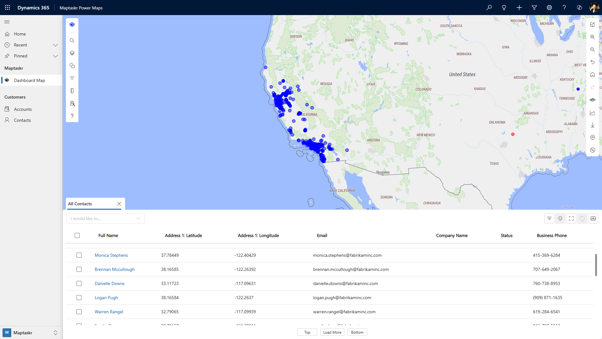
| Overlay Bottom | The data tab appears as an overlay at the bottom of the map |
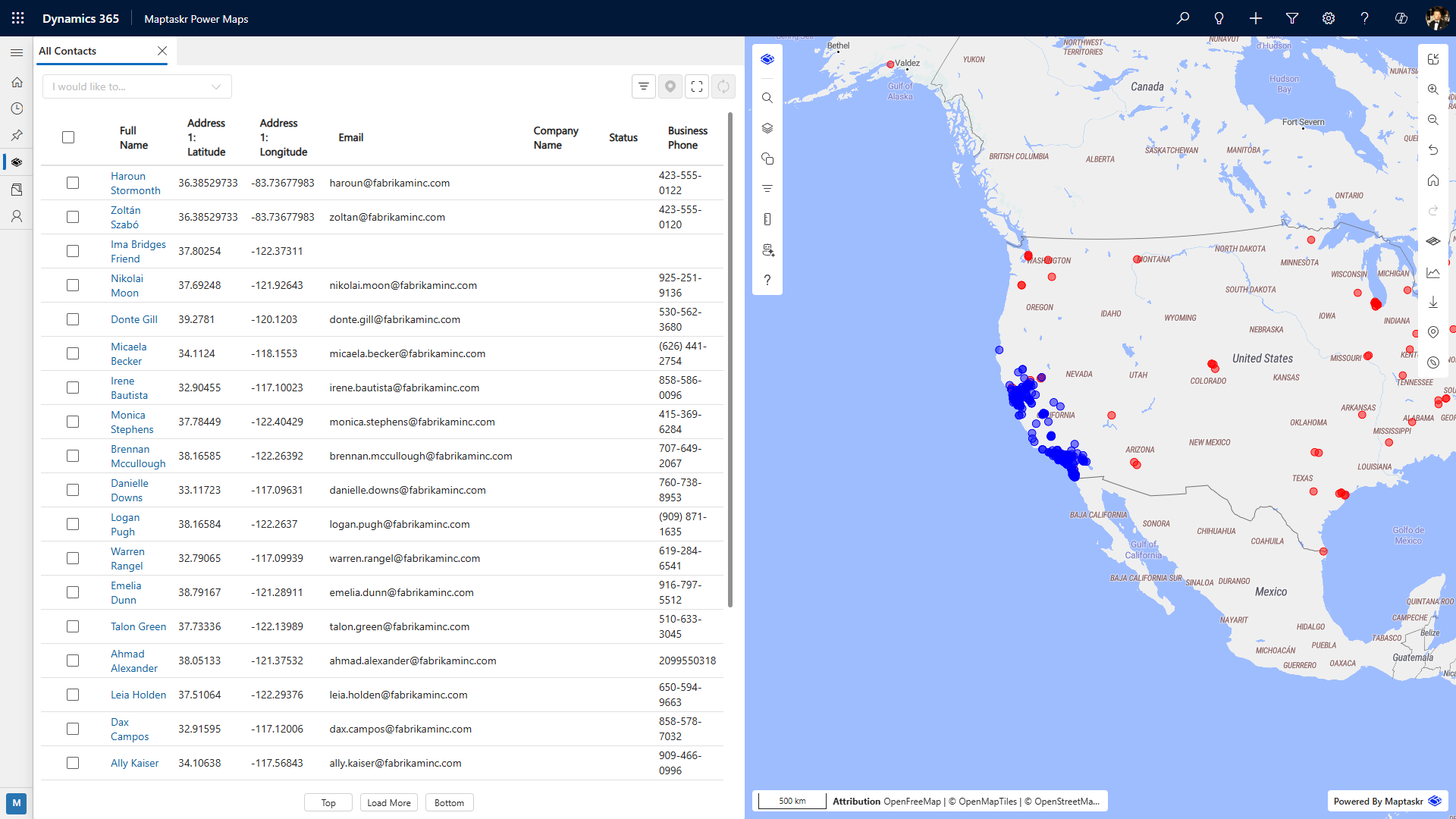
| Dock Left | The data tab is docked to the left side of the map interface |
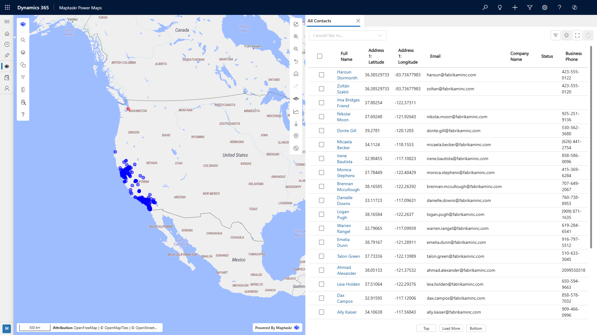
| Dock Right | The data tab is docked to the right side of the map interface |
Visual Examples
Overlay Bottom
Dock Left
Dock Right
Map Tooltips
Display Tooltips
When enabled, users can see tooltips on enabled layers within the map.
Display Tooltips on Shapes
When enabled, the user will be able to see tooltips on enabled shapes on the map.